Stream Corridor Decision — The Single Highest-Leverage Routing Choice
Rev: v2.0 · Updated: 2026-05-29
Latest Gulf Stream snapshot — 2026-05-30 · generated by the gulfstream-monitor skill from 6 sources (Rutgers, NCOM, RTOFS, SPoRT, AOML altimetry, Frank Bohlen)
North wall at 37°N: ~−68.5°W consensus — RTOFS −68.0; Rutgers/SPoRT −68.5; NCOM −68.7; altimetry −69.0 (essentially on the rhumb, −68.0°W) South wall at 37°N: ~−66.5°W (Rutgers/NCOM/altimetry −66.5; RTOFS −66.8) Eddies in corridor: 1 persistent cold-core ring at ~35°30′N, 68°45′W (just west of the rhumb), counter-clockwise, nearly stationary for months and expected to still influence the optimum route after the 19 June start — its ~2 kt local set is part of a large band of adverse NW-going current extending >200 nm along the rhumb (per Bohlen, GS Note #2, 4 Jun). Altimetry-only (SST cloud-obscured). Meander axis: a meander crest crosses the rhumb near 38°N, 68°45′W with near-perpendicular W→E flow (the cleanest crossing point); north-bulging warm meander east of ~−66°W; meander pattern changing unusually fast week-to-week (Bohlen: rapid, "to some extent unusual" evolution).
Cross-source agreement: - North-wall longitude spread ~1.0° (RTOFS −68.0 vs altimetry −69.0 — above the 0.3° threshold): the cold-core ring sits on the wall near the rhumb, so sensors place the effective wall differently. - The cold-core ring is altimetry-only; SST cannot resolve it through cloud (consistent with Frank Bohlen's note).
Frank Bohlen's most recent note — GS Note #2 (4 Jun 2026): the counter-clockwise cold-core ring at ~35°30′N, 68°45′W has held nearly stationary for months (entrainment in the main Stream offsetting its density-driven westward drift) and is likely to still affect the optimum route after 19 June. The meander crest crosses the rhumb near 38°N, 68°45′W; combined, they produce a large area of adverse NW-going current extending >200 nm along the rhumb — an adverse flow for boats Newport→Bermuda. On the models he ranks: NOAA GRTOFS obscures the feature (minimal detail); Copernicus/Mercator best represents the consensus (though "ephemeral" and poor on the persistent ring's rotation); altimetry trusted throughout. Watch altimetry + SST + Copernicus right up to the start, and study the 500 mb contours.
Pre-race research (RRS 41): a snapshot of current Stream state, not race-period routing advice. Raw artifacts (local only, gitignored):
data/gulfstream-monitor/2026-05-30/.
The Gulf Stream crossing consistently moves boats up or down the corrected-time leaderboard. For every year 2012–2024 this page shows where the strict cohort (40–45 ft, Lupo's LOA neighbours) crossed 37°N — and what their corridor choice cost or gained in corrected time.
Map corridor legend: - 🔴 RED: crossed 37°N east of −67.5°W (east corridor) - 🟡 GOLD: crossed 37°N inside the rhumb band (−68.5 to −67.5°W) - 🔵 BLUE: crossed 37°N west of −68.5°W (west corridor) - Dashed white = rhumb line. Corridor bands = ±30 nm of rhumb at 37°N.
Rhumb at 37°N: −68.03°W. Anything outside ±30 nm is a positional commitment that must pay back its detour cost.
TL;DR
- Hold rhumb by default — median-best or tied in 4 of 6 years (2024, 2018, 2016, 2014).
- Go EAST only on a confirmed eastern feature (eddy / meander limb). 2022 is the one textbook case: EAST 59.45 h median, the fastest in the set — but EAST is n=29 only in 2022; n=1–2 every other year, so treat it as a single confirmed example, not a trend.
- WEST is almost always a cost — ~15.7 h vs east in 2022, ~5 h vs rhumb in 2016 (RTOFS-only signal), plus the highest retirement rate (10–25%).
- Medians are within-year (different wind regimes) — not cross-year speed-comparable.
All six winners + the crossing corridor, on one map
Interactive — toggle layers at top-right. Dashed white = rhumb; the shaded gold band is the RHUMB corridor (±30 nm at 37°N), with the EAST (red) and WEST (blue) boundaries; colored lines are each year's corrected-time winner, and each tooltip says which corridor that winner crossed at 37°N. Four of six held the RHUMB band; 2022 Illusion went EAST (the 7-hour eddy hold) and 2018 Grundoon went WEST (light-air pressure). The shaded rectangles are the known current traps (2016/2022 cold-core rings, the 2018 parking lot). The current field is a separate precise layer — now built, the GLORYS flow field below; this map deliberately carries no satellite raster, since the served SST/current images aren't georeferenced and a fuzzy overlay under a precise route is the very 2016 "trust RTOFS alone" trap. Pre-race research only (RRS 41).
Watch the Stream set up — daily evolution loop
How the Gulf Stream's meander and its warm- and cold-core eddies migrate over the current day plus the previous 7 (an 8-day rolling window) into the start. Each frame is one day's NOAA AOML CoastWatch altimetry current field (cloud-immune, altimetry-derived — no satellite gaps); the loop holds on the most recent day. Watch where the rings drift relative to the 37°N crossing line: an eddy that parks on the rhumb is the kind of confirmed feature that justifies an EAST commitment (the 2022 case), and a cold ring sliding onto the corridor is the 2016 west-side trap forming.
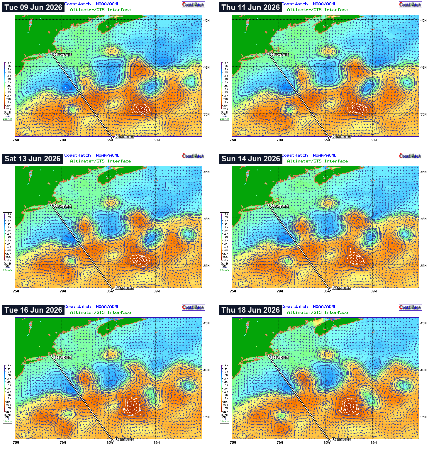
Frozen, committed animation (regenerated locally as new daily frames land; it stops updating before the June 19 start — pre-race research only, RRS 41). Read the eddies and the Stream axis here, then take corridor commitments to the precise geometry on the map above. The single most-recent snapshot also rides each daily brief's mini-map as a toggleable overlay.
The same window in sea-surface temperature — the RUCOOL/Rutgers GOES SST map the daily brief shows, looped across the current day plus the previous 7. Altimetry (above) sees current structure through cloud; SST shows the thermal Stream and its warm/cold rings directly, but with gaps on cloudy days ("no cloud correction applied" — those white patches are the missing signal, not slack water).
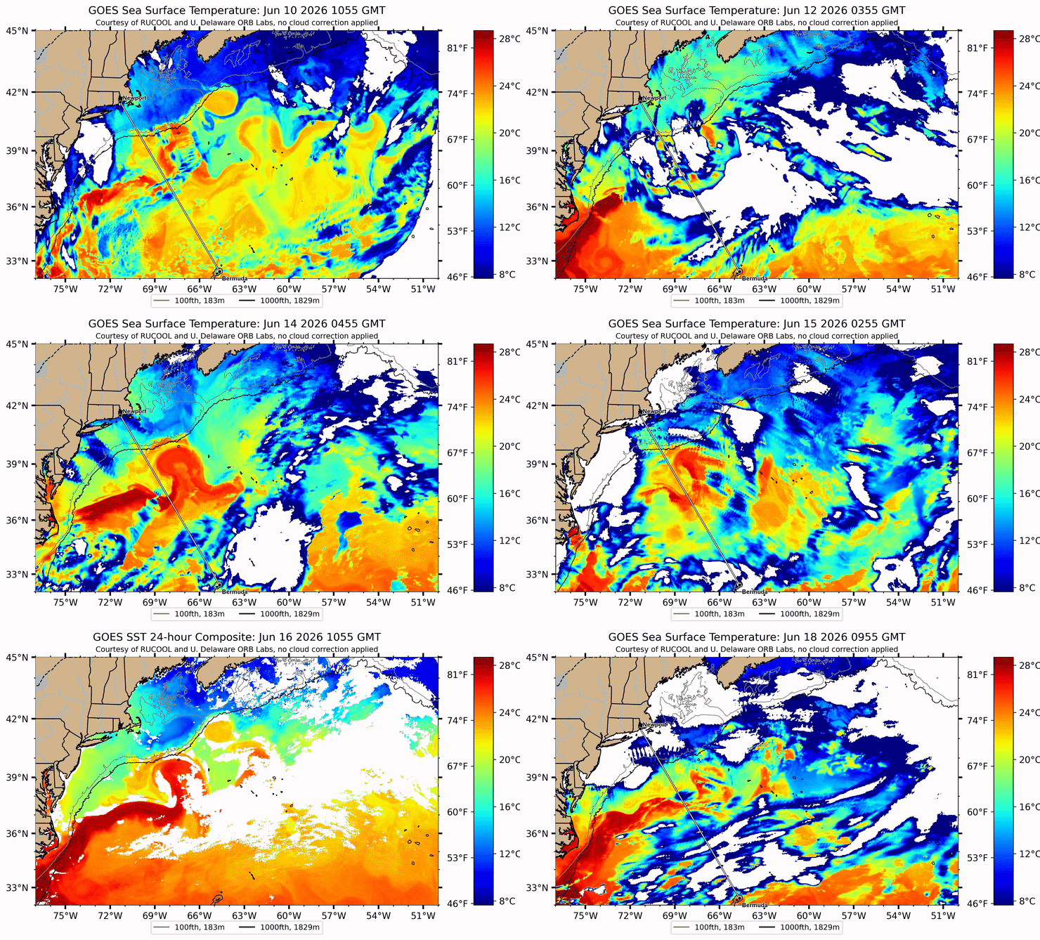
Frozen, committed animation (regenerated locally each day from the brief's clearest-pass GOES SST; stops before the June 19 start — RRS 41). Read it together with the altimetry loop: where a warm tongue and an altimetry eddy line up is a confirmed feature; where SST is cloud-blanked, trust the altimetry.
Defined current field — GLORYS (the Expedition look)
The precise, georeferenced current layer: an animated 1/12° surface-current flow field from Copernicus GLORYS — the source Frank Bohlen ranks above RTOFS (he's openly "suspect" of RTOFS, which over-believes meander dips the altimetry/GLORYS don't support). This is the "defined current + route" view you'd build in Expedition, in the browser: watch the Stream axis and its warm/cold rings, and where the meander crosses the rhumb at 37°N. Click anywhere to read the local set/drift.
Animated GLORYS surface current (purple = fastest, ~2 kn+; the Stream axis and rings stand out against the slack background) under the rhumb + RHUMB corridor + 37°N line. Frozen/committed — regenerated locally as new GLORYS days land; stops before the June 19 start (RRS 41). The current field's structure here is the confirmation the if-then playbook calls for before committing east of rhumb.
The green line is a current-optimal crossing — a Zermelo
least-time path computed through this GLORYS field at a fixed boat speed (scripts/analysis/current_optimal_route.py).
For this snapshot it goes EAST (crosses 37°N near 66.8°W) to dodge the cold-core ring's adverse
N/W set on the rhumb and ride the favourable meander limb — saving ~2 h vs the straight rhumb at
8 kn. Read it honestly: this is current-only over a frozen snapshot — it ignores wind and VMG,
which is precisely why Bohlen stays reluctant to chase east (the SW'ly beat-back the current model
can't see is what usually eats the gain). It's a crossing hypothesis to confirm against the wind,
not a race route — the wind-fed optimisation is Expedition's job (Lupo's navigator).
Watch it evolve — 8-day GLORYS loop
The map above is a single most-recent day. This animated loop steps through the current day plus the previous 7 — GLORYS surface current over its SST field — the precise-current companion to the altimetry evolution loop above. Watch the meander axis and its warm/cold rings migrate relative to the 37°N crossing.
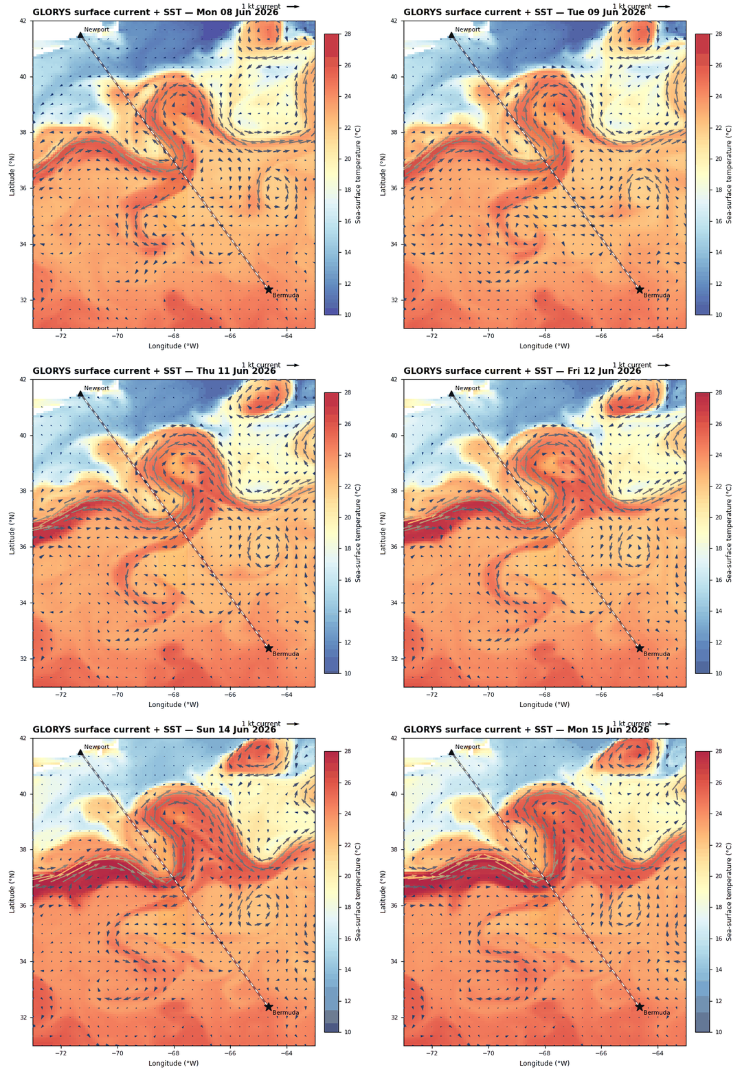
Frozen/committed — regenerated locally each day from Copernicus GLORYS (≈3-day NRT lag, so "current" = latest available); stops before the June 19 start (RRS 41).
Aggregate findings across 6 races
Medians are within-year (each year is a different wind regime) and are not cross-year speed-comparable. EAST is statistically meaningful only in 2022 (n=29); n=1–2 every other year.
| Year | Pattern | Best corridor (cohort median corrected) | West penalty | East verdict |
|---|---|---|---|---|
| 2022 | W-PF / forming CCR | EAST 59.45h (n=29) | WEST cost ~15.7h vs east | East paid — eddy/meander limb |
| 2016 | W-PF / W-CC (CCR trap) | RHUMB 78.7h | WEST cost ~5h vs rhumb | East n=1 — no signal |
| 2024 | W-PF / W-BH reaching, meander | RHUMB 67.7h (WEST 67.2h tied) | West essentially tied | East n=1 outlier |
| 2018 | W-LA parking-lot | RHUMB 93.5h | WEST cost ~4h | EAST cost ~2h (n=2) |
| 2014 | W-LA light air, frontal east shutoff | RHUMB / WEST tied at 124.0h | No penalty | East n=0 (no boats) |
| 2012 | W-PF reaching, benign Stream | WEST 84.9h (n=6) — slight | None | East n=0 (no boats) |
Synthesis:
- RHUMB is the default that wins by default. In 4 of 6 years rhumb was median-best or tied. Boats that held rhumb without chasing features finished well-clustered around the cohort median.
- EAST is the high-value play when an eddy or meander limb is confirmed — 2022 was textbook: 29 cohort boats went east; median corrected (59.45h) was the lowest in the entire dataset. But 2022 is the only year with a meaningful east sample (n=29); every other year is n=1–2, so this is one confirmed example, not a pattern. Without confirmation, going east is a coin flip.
- WEST is almost always a cost. In 2016 and 2022 it was a clear penalty (~5h vs rhumb and ~15.7h vs east). The 2016 case is the textbook CCR-trap: RTOFS predicted a west-side current that didn't materialize.
- Light-air years (2014, 2018) collapse the differences. Wind is the binding constraint; corridor choice matters less — but rhumb-default still holds.
Tactic correlation: → Routing Tactic Catalog
Retirement rates: another reason west costs
| Year | EAST started/retired | RHUMB started/retired | WEST started/retired |
|---|---|---|---|
| 2024 | 1 / 0 (0%) | 57 / 5 (9%) | 4 / 1 (25%) |
| 2022 | 29 / 1 (3%) | 32 / 3 (9%) | 4 / 1 (25%) |
| 2018 | 2 / 0 (0%) | 44 / 5 (11%) | 8 / 1 (12%) |
| 2016 | 1 / 0 (0%) | 21 / 0 (0%) | 28 / 5 (18%) |
| 2014 | 0 | 28 / 0 (0%) | 41 / 4 (10%) |
| 2012 | 0 | 63 / 16 (25%) | 8 / 2 (25%) |
West-corridor retirement rate (10–25%) is consistently the highest. The east corridor's retirement rate is near-zero in the years where it's populated.
The 2016 row: of 28 cohort boats that committed west, 5 retired (18%) and the rest lost ~5 hours. Both outcomes were worse than rhumb (0/21 retired, faster median).
2012 RHUMB 25% retirement: likely YB tracking gaps, not a lesson.
Per-year corridor analysis
2024 — Reaching year, strong meander on east limb
Pattern: W-PF / W-BH. Strong Stream current (up to 5 kt NE) in an eastward meander. Key split: when to exit the meander, not east-vs-west.
| Corridor | started | finished | retired | P10 → P50 → P90 corrected | Read |
|---|---|---|---|---|---|
| EAST | 1 | 1 | 0 | 86.4 / 86.4 / 86.4 h | Outlier; no signal |
| RHUMB | 57 | 52 | 5 | 64.5 / 67.7 / 72.9 h | Default; tight cluster |
| WEST | 4 | 3 | 1 | 66.6 / 67.2 / 69.1 h | Tied with rhumb on median |
Carina (corrected winner, 64h 12m) rode the meander and exited before being set too far east. See Card 06.
2022 — Forming CCR, the year the east corridor paid
Pattern: Post-frontal NW with a forming cold-core ring near the rhumb crossing latitude. Ring's western limb was the trap; eastern limb (and surrounding NE-flowing meander) was the prize.
| Corridor | started | finished | retired | P10 → P50 → P90 corrected | Read |
|---|---|---|---|---|---|
| EAST | 29 | 29 | 1 | 52.6 / 59.4 / 67.9 h | Best — eddy/meander limb; tight spread |
| RHUMB | 32 | 30 | 3 | 56.7 / 60.6 / 80.4 h | Default; wide P90 — some caught in CCR adverse interior |
| WEST | 4 | 3 | 1 | 64.7 / 75.1 / 77.8 h | 15h penalty — the CCR-limb trap |
East corridor's P10–P90 spread (52.6→67.9h) is tighter than rhumb's (56.7→80.4h). Strongest signal in any year. Illusion (Cal40, Stan Honey) is the corrected winner.
2018 — Light-air parking-lot year
Pattern: W-LA. Wind was the binding constraint. Strong NE-flowing current helped everyone in the core, but corridor differences washed out under light-air variance.
| Corridor | started | finished | retired | P10 → P50 → P90 corrected | Read |
|---|---|---|---|---|---|
| EAST | 2 | 2 | 0 | 89.0 / 95.4 / 101.9 h | Negligible sample |
| RHUMB | 44 | 39 | 5 | 82.3 / 93.5 / 111.4 h | Best median but wide P90 — light-air variance |
| WEST | 8 | 7 | 1 | 82.0 / 97.6 / 103.0 h | ~4h cost on median |
Grundoon (Columbia 50) won by light-air specialization, not corridor commitment. See Card 07.
2016 — The CCR trap that confirmed west = risk
Pattern: Pre-frontal southerly → post-frontal NW. Partially-formed cold-core ring near the rhumb. RTOFS predicted favorable current on the western limb. RTOFS was wrong by 20–40 nm.
| Corridor | started | finished | retired | P10 → P50 → P90 corrected | Read |
|---|---|---|---|---|---|
| EAST | 1 | 1 | 0 | 77.3 / 77.3 / 77.3 h | Singular data point |
| RHUMB | 21 | 21 | 0 | 70.9 / 78.7 / 85.7 h | Best — zero retirements |
| WEST | 28 | 23 | 5 | 78.0 / 83.7 / 93.4 h | 5h cost + 18% retirement — the CCR-trap signature |
RTOFS alone is not a safe basis for a west-corridor commit — cross-validate with SST and AVISO altimetry. Warrior Won (Xp44) won by holding rhumb. See Cold Core Ring Guide.
2014 — Light air, frontal zone east shutoff
Pattern: W-LA / W-PF. A frontal zone shut down wind on the east side mid-race.
| Corridor | started | finished | retired | P10 → P50 → P90 corrected | Read |
|---|---|---|---|---|---|
| EAST | 0 | 0 | 0 | — | Zero cohort boats committed east |
| RHUMB | 28 | 28 | 0 | 116.8 / 124.0 / 129.5 h | Tied for best; zero retirements |
| WEST | 41 | 37 | 4 | 116.6 / 124.0 / 131.9 h | Tied on median; 10% retirement rate |
2012 — Benign Stream, reaching race
Pattern: W-PF / W-BH. Normal Stream, no significant features. Race decided by boat speed and maneuver discipline.
| Corridor | started | finished | retired | P10 → P50 → P90 elapsed | Read |
|---|---|---|---|---|---|
| EAST | 0 | 0 | 0 | — | Nobody east |
| RHUMB | 63 | 47 | 16 (25%) | 75.9 / 87.8 / 111.5 h | Default; high retirement is YB data-quality caveat |
| WEST | 8 | 6 | 2 (25%) | 79.8 / 84.9 / 101.2 h | Slight median edge; small n |
Carina (Reichel/Pugh) won on simplicity: ~2 jibes and 2 tacks for 636 nm.
Implications for 2026
The corridor decision for Lupo hinges on three things, in order of decisiveness:
- CONFIRMED favorable eastern feature in 36–38°N band? Eddy or meander limb confirmed by SST composite + AVISO altimetry + RTOFS agreement → east is the high-value play (2022 pattern). Never commit east on RTOFS alone.
- CONFIRMED adverse western feature (CCR west of rhumb)? Do not chase it as a detour target without 3-source confirmation. The 2016 cohort lost 5 hours doing exactly this.
- Otherwise, hold rhumb. Median-best or tied in 4 of 6 years.
Threshold for committing east: feature must look strong enough to deliver ≥2–3h corrected-time edge. Without confirmation, not worth committing.
Threshold for going west: essentially never as a current play. Only justifiable west commit is a pressure play (2014-style frontal-zone east shutoff) — and even then the gain over rhumb was zero.
How far west, ever: ~30 nm — the edge of the rhumb corridor. Treat the −68.5°W WEST boundary (±0.5° longitude = 30 nm at 37°N) as the practical outer limit, and only push toward it for a confirmed pressure play, never for current. The evidence behind the cap: the 2016 cohort that dove 30–50 nm west chasing an RTOFS-only cold-core-ring limb (RTOFS was 20–40 nm off) lost ~5h and retired at 18%. If a ring's western limb is ever worth exploiting, all four must hold — CCR confirmed by SST and altimetry (not RTOFS alone), limb within 40 nm of the rhumb crossing, routing shows >6h net gain after maneuver cost, and wind supports the angles. Absent all four, do not cross the −68.5°W line.
On-watch sequence at crossing: Card 03 → Card 04 → Card 05 → Card 06
Feature identification: Cold Core Ring Guide · Warm Core Eddy Guide · RTOFS Interpretation
Analysis basis: YB tracker binaries 2012–2024. Ratings: TCF1 (2024, 2016, 2014), ORC GPH (2018), bermudarace.com (2022), line-honours fallback (2012). Cohort: strict 40–45 ft LOA (sizes: 2024=64, 2022=67, 2018=54, 2016=67, 2014=70, 2012=71).
Sources
- Corridor medians, percentiles & retirement counts —
scripts/analysis/stream_corridor_analysis.pyover YB tracker binaries 2012–2024 (strict 40–45 ft cohort); cached indata/yb_cache/stream_corridor_stats.json. - Weekly Gulf Stream snapshot —
scripts/gulfstream_monitor/fetcher.py+ thegulfstream-monitorskill (rewrites the snapshot block above). - Feature ID & RTOFS interpretation — gulf_stream_framework.md (#ccr · #wce · #rtofs).
- W-* pattern tags & winner tactics — weather_analog_framework.md, winner_route_summary.md, routing_tactic_catalog.md.
- Forecast → analog pipeline —
scripts/daily_brief.py, forecast_analog_matcher.md.
PRE-RACE RESEARCH — not race-period routing advice. Updated 2026-05-29.